 |
|
|
MIAMI RIVER COMMISSION| JAMES MURLEY, CHAIR
Urban Infill Minutes 2012 |
- May 16, 2012
- August 9, 2012
I. Projects
A.Review Proposed Surface Parking Lot, 431-451 S. Miami Ave - Mr. Brett Bibeau, MRC Managing Director, stated the MRC had received the distributed written notification from the City of Miami, which is requesting the MRC’s advisory recommendation on a pending application for a 144 parking space parking on the large unimproved vacant lots on the south shore, between South Miami Ave bridge and the “5 ST” Metro-Mover Station. Director Bibeau presented City of Miami’s Miami 21 Zoning Code section 3.11 “Waterfront Standards” which requires a public riverwalk on this site, along with the City charter requirements for any potential surface parking to be setback 50-feet from the seawall. In addition section 3.11 states, “All Miami riverfront properties shall include water related uses”. Miami 21, Article 4, Table 3, indicates surface parking is not as of right on this site, rather only “Allowed by Warrant: Administrative Process – CRC (Coordinated Review Committee)”, which is the process currently underway. Attendees noted although the proposed surface parking lot plans depict the required 50 foot setback from the seawall, the setback area indicates “Future Riverwalk”. The proposal is to make the riverfront surface parking lot up to code in phases, over 5 years, as follows:
“Year One: will install an Aluminum picket fence
Year Two: install lighting, will cover the lot with crushed asphalt to create level. Tripe the new surface
Year Three: Landscaping
Year Four: asphalt over the entire parking area & re-stripe the lot
Year Five: drainage and asphalt over the entire parking area & re-stripe the lot in full compliance with Miami 21 Code”
Attendees noted this site has existing riverwalk proceeding east, and the Miami River Greenway is currently under construction to the west, starting at the South Miami Ave Bridge. Therefore this site is essentially a missing piece in-between two sections of the public Miami River Greenway system. Chairman Murley asked considering the proposal is not allowed by right, what are the criteria by which the City considers the merits of the proposal to permit construction of a surface parking lot on this riverfront site, and Director Bibeau replied he was unaware of any specific criteria. UIWG Chairman Murley suggested the MRC recommend the City create, and or provide the criteria for considering this waterfront surface parking lot before rendering a decision. In addition, UIWG Chairman Murley suggested the MRC recommend the City require construction of a temporary public riverwalk in “Year One or Two”, with the specific proposed temporary public riverwalk design to be presented to the MRC first, followed by the permanent public riverwalk, per the City’s adopted standards, to be constructed no later than “Year Five”. This item will be considered during the full MRC’s public meeting on June 4, noon, 1407 NW 7 Street.
II. Plans
A. Update Regarding Implementing Adopted Miami-Dade County Palmer Lake Charette Area Plan – Mr. Jess Linn, Miami-Dade County Planning Department, stated the Board of County Commissioners recently adopted the Plan, and the next Steering Committee meeting is June 11, 3 PM, 2257 NW North River Drive. Director Bibeau stated the Steering Committee was previously presented the draft ordinance which would replace the existing zoning code for all parcels in the entire study area, and he recommended the County take equal steps to implement the remaining action items in the adopted plan, in addition to the new zoning.
Director Bibeau distributed the revised page 40 of the adopted plan, which is a cross section of the on-road Miami River Greenway along NW South River Drive within the study boundary. Mr. Bibeau stated the 3.5 miles of the Miami River Greenway have been constructed to date in areas with only 50 feet of public right of way (ROW), and the subject area has 60-70 feet of public ROW. Mr. Bibeau stated within the large public ROW, many of the narrow riverfront businesses have needed employee parking, which the proposed rendition would eliminate and replace with 2 bike lanes etc, which are not featured in the existing sections of the Miami River Greenway which has one, wide, mixed-use, mesa-beige pathway.
Mr. Linn stated the Plan’s referenced South River Drive cross-section is not set in stone, he has no objection to revising it, and it will most likely change. Mr. Bibeau cited the Palmer Lake Charrette Area Plan’s March 19, 2012 public meeting minutes, “Jeff Cohen (MDC Public Works) then stated that the Tamiami Canal swing bridge is to be replaced, and will include a multi-use path (Miami River Greenway) that would continue along the south side of NW South River Drive. Mr. Linn requested that any specific information available regarding roadway improvements within the Palmer Lake area be provided to planning staff.” Mr. Bibeau stated the Tamiami Swing Bridge’s PDE cross section was more consistent with the current 3.5 miles of the Miami River Greenway, as it is one, wide, mesa-beige, mixed-use path, which only in this industrial upper river section is located on the upland side of NW South River Drive. UIWG Chairman Murley suggested the MRC encourage Miami-Dade County to work with riverfront South River Drive property owners and the MRC on refining implementation of the County’s adopted Miami River Greenway Action Plan and Palmer Lake Charette Area Plan, along NW South River Drive, from the Tamiami Swing Bridge to NW 25 ST, to include more on-street parking in the extra ROW while constructing the on-road Miami River Greenway.
B. Review Draft Miami-Dade County Evaluation Appraisal Report (EAR) Based Amendments to the Comprehensive Plan – Ms. Helen Brown, Miami-Dade County Department of Planning and Zoning, distributed copies of the following draft EAR based amendments to the Comprehensive Plan:
PORT OF MIAMI RIVER SUBELEMENT
Introduction
The material presented in this Sub element is limited in scope to the shipping facilities found along the Miami River that serve shallow draft vessels. These shipping terminals were together formally designated as the Port of Miami River to meet regulations of the U.S. Coast Guard.
The Plan
In general, the Port of Miami River Sub element promotes continued maritime business and traditional marine-related shoreline uses as well as the protection of environmental resources on the Miami River. The Plan for the Port of Miami River is expressed in the following goal, objectives and policies, and monitoring program.
GOAL: MAINTAIN AND ENHANCE THE WATER QUALITY, ATTRACTIVENESS AND ECONOMIC VIABILITY OF THE PORT OF MIAMI RIVER.
Objective PMR-1
Maintain and promote marine activity on the Miami River and protect these activities from encroachment or displacement by incompatible land uses.
POLICIES
PMR-1A. Miami-Dade County shall promote actions to enhance establish a marine industrial/commercial activities district along the banks of the Miami River west of NW 27 Avenue and in other areas along the Miami River where feasible.
Per-EAR This policy should be revised for the County to promote actions which maintain and enhance marine industrial activities along the banks of the entire Miami River and not just a marine/industrial district.
PRM-1B. In making recommendations relating to requested zoning changes and permits for development and redevelopment along the Miami River, Miami-Dade County agencies shall promote the protection or inclusion of uses which are water dependent and/or water related, such as cargo shipping terminals and boat repair yards.
Objective PMR-2
Actions shall be taken to improve linkages between the shipping terminals on the Miami River and surface transportation routes and modes.
Policies
PMR-2A Initiate a Miami-Dade County and the Miami River Commission shall monitor the implementation of the Miami River Corridor Multimodal Transportation Plan Study with cooperation and assistance of all concerned agencies (i.e. County, City, MPO, FDOT, MDX, US Coast Guard, etc.)
Per EAR This policy should be modified to acknowledge the existence of a multi-modal transportation plan, which also incorporates the Miami River Greenway Action Plan and the relationship between the existing/proposed Greenway sections and multiple modes of transportation along the corridor.
PMR-2B In cooperation with other concerned agencies and organizations, Miami-Dade County shall investigate and implement ways of improving roadway access between the Port of Miami River shipping terminals and the adjacent surface transportation system.
PMR-2C Miami-Dade County shall work with the Miami River Commission, the Miami River Marine Group, and other concerned agencies and organizations to improve the vitality of the Port of Miami River and to minimize traffic conflicts on adjacent roadways.
Objective PMR-3
The Port of Miami River shall be operated in a manner which minimizes impacts to estuarine water quality and marine resources and adjacent land uses.
Policies
PMR-3A Miami-Dade County shall continue to place high priority on having the polluted sediments removed from the Miami River including all of its tributaries which impact water quality.
Per EAR It is recommended that this policy be modified to include the dredging of the tributaries which impact the quality of the water in the Miami River.
PMR-3B Miami-Dade County shall stabilize all eroding County-owned shoreline areas and rights-of-way along the Miami River consistent with available funding, and the County shall develop an ordinance requiring shoreline stabilization where necessary on public and private sites along the river.
PMR-3C The Miami-Dade County Department of Environmental Resources Management shall ensure that stormwater runoff from future industrial uses shall be contained on site and not discharged to the River. An on-site retention system combined with an overflow outfall may be considered as an alternative to full on-site retention in those cases where a higher degree of flood protection is desired and maintenance of water quality is assured.
PMR-3D. Miami-Dade County through its program of stormwater outfall removal and retrofitting shall eliminate detrimental stormwater outfalls along the Miami River by 2005.
PMR-3E. Additional policies included in the Coastal Management Element regarding dockside pump out facilities, bulkhead repair and construction and enforcement activities along the Miami River are hereby incorporated in the Sub element by reference.
Objective PMR-4
The Port of Miami River, through the owners and operators of its international shipping terminal facilities regulated by the Maritime Transportation Security Act, with assistance from the Miami River Commission (MRC) and Miami River Marine Group (MRMG), shall recognize local, State and Federal security needs in all port operations, expansion and new construction.
Policies
PMR-4A The Port of Miami River, through the owners and operators of its international shipping terminal facilities regulated by the Maritime Transportation Security Act, shall annually audit operations of the Port of Miami River in light of the Miami River Port Security Plan and any new local, State and Federal security requirements.
PMR-4B The County, MRC and MRMG shall seek funding from local, State and Federal sources to address domestic homeland security issues.
PMR-4C The Port of Miami River, through the owners and operators of its international shipping terminal facilities regulated by the Maritime Transportation Security Act, with assistance from the MRC and MRMG shall ensure that new projects are designed and constructed in accordance with the Miami River Port Security Plan, as approved by the Miami River Security Committee on June 8, 2004, and applicable local, State and Federal security laws.
PMR-4D In the event of an apparent conflict between the Miami River Port Security Plan, approved by the Miami River Security Committee on June 8, 2004, local, State and Federal law and/or agency directives, and other objectives in any Sub element, the Homeland Security-based requirements shall prevail.
Future Port of Miami River
The Port of Miami River is expected to retain its share of the growing international trade activity occurring in Miami-Dade County. The banks of the Miami River west of NW 27 Avenue and east of the salinity dam will remain the predominant area for shipping facilities serving the small ports of the Caribbean. This western section of the Port of Miami River is recommended to be used only for marine industrial and commercial activities. The role of Miami-Dade County in maintaining maritime facilities in this port area is limited to that of facilitator, as Miami-Dade operates its own seaport facilities on Dodge and Lummus Islands. Miami-Dade will continue to facilitate marine activity on the Miami River through its legislative function of establishing and implementing land use policy, and in its administrative functions in providing and maintaining roadway infrastructure which provides landside access to the area.
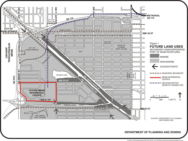
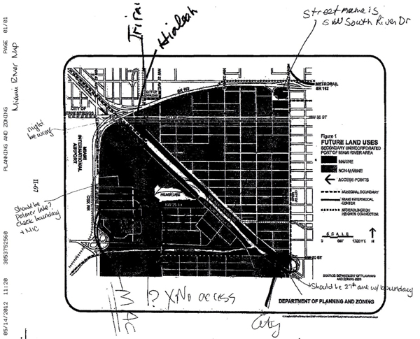
Future land use in the Miami River area is depicted on the Land Use Plan map in the Land Use Element. Figure 1, which follows, also highlights those sites along the banks of the unincorporated portion of Port of Miami River area which should be reserved for continued commercial marine activity. Figure 1 also identifies points of highway access to the area and rail lines. Future natural resources of the area are mapped in the future natural resources map series in the Land Use Element.
Facility improvements planned by Miami-Dade County that will impact this area are primarily roadway projects. These are listed in the County’s Transportation Improvement Program and the Miami-Dade Transportation Plan to the Year 2030. Overall, those projects will relieve congestion at points of access to the unincorporated Port of Miami River area and will enhance circulation through the area by replacing inadequate bridges and adding a new river crossing in the NW 32 Avenue corridor. Miami-Dade County will ensure that the new crossing provides for continued navigation upstream.
Port of Miami River Monitoring Program
The monitoring measures for the objectives of this Sub element are the following:
Objective PMR-1
- Indices showing the growth or shrinkage of the amount of river frontage devoted to marine related/dependent business activity shall be prepared biennially.
- Records of land use changes in the vicinity of the Miami River in unincorporated Miami-Dade County since 2003.
- Records of zoning changes in the vicinity of the Miami River in unincorporated Miami-Dade County since 2003.
Objective PMR-2
- The number of ships, tonnage, types of cargo, and the value of cargo handled shall be reported. Numbers of full-time and part time employment at the shipping terminals, and an estimate of the annual payroll for each category, shall also be reported. These data shall be sought from the Miami River Commission and the Miami River Marine Group.
- The Department of Planning and Zoning in conjunction with the Florida Department of Transportation, the Metropolitan Planning Organization, The Miami River Commission and the Miami River Marine Group will prepare transportation improvements updates listing completed, underway, programmed and planned transportation improvements of significant repercussion to the Port of Miami River.
Objective PMR-3
- The County's Department of Environmental Resources Management (DERM) shall list progress on shoreline stabilization, stormwater runoff, outfall removal/refitting and overall water quality along the navigable portion of the Miami River and its tributaries. Per EAR The first monitoring measure should be revised to include the tributaries
- Additional monitoring measures included in the Coastal Management Element regarding water quality and protection of natural resources, as related to the Miami River west of NW 27 Avenue, are adopted by reference.
Objective PMR-4
- Compliance with applicable security requirements, Maritime Transportation Security Act and the Miami River Port Security Plan.
UIWG Chairman Murley suggested the MRC find the County’s proposed EAR based amendments to the Comprehensive Plan consistent with the Miami River Corridor Urban Infill Plan and the Miami River Greenway Action Plan. Director Bibeau stated this item is prepared to be placed on the MRC’s June 4 public meeting agenda. Ms. Brown asked for it to be considered during the MRC’s July public meeting instead.
III. New Business – UIWG Chairman Murley extended an invitation for the MRC to participate in the South Florida Regional Planning Council’s (SFRPC) State Road 7 Corridor Redevelopment Strategy Workshops at 6 PM, on May 22, June 5 and June 19, in the Arcola Lakes Library, 8240 NW 7 Ave. UIWG Chairman Murley noted the southern terminus of the study is the Miami River’s north shore. As stated in the distributed SFRPC memo, the goal is to “enrich regional transportation and redevelopment opportunities along State Road 7 (7 Ave)…Once this information is gathered the SFRPC will use it, in conjunction with the Cities, County and transportation and economic development organizations to prepare and submit funding proposals to implement the identified community-based solutions.”
The meeting adjourned.
|
May 16, 2012 | THIS IS A PUBLIC DOCUMENT
The Miami River Commission’s (MRC) Urban Infill Working Group (UIWG) convened a public meeting on May 16, 2012, 9 AM, in the Robert King High Classroom, 1407 NW 7 Street.
UIWG Chairman Jim Murley chaired the meeting and the attendance sheet is enclosed. |
I) Review 2nd Draft Miami-Dade County New Zoning Code “Article XXXIII(S) Palmer Lake Metropolitan Urban Center District” – Attendee’s reviewed the distributed 2nd draft Miami-Dade County New Zoning Code, “Article XXXIII(S) Palmer Lake Metropolitan Urban Center District”. MRC Managing Director Bibeau stated at the last Palmer Lake Steering Committee meeting, Miami-Dade County staff estimated the distributed draft ordinance will be considered by the Board of County Commissioners this calendar year, first to create the proposed new zoning district. Miami-Dade County Planning staff estimated 2 months later the Board of County Commissioners will consider deleting the existing zoning for every parcel in the Palmer Lake Study Area, and replacing it with this new, proposed zoning district. Later in the Palmer Lake Steering Committee meeting, Miami-Dade County Planning staff stated parcels could opt- out of the new zoning by requesting so in writing, and they would then maintain their existing zoning. Director Bibeau indicated Miami-Dade County Planning staff requested his written comments on the 2nd Draft Miami-Dade County New Zoning Code “Article XXXIII(S) Palmer Lake Metropolitan Urban Center District” by August 13. UIWG Chairman Murley suggested the MRC recommend approval of the 2nd Draft Miami-Dade County New Zoning Code, “Article XXXIII(S) Palmer Lake Metropolitan Urban Center District”, subject to the following conditions:
1) Amendments are needed to become consistent with Miami-Dade County’s adopted Miami River Greenway Action Plan, the voter approved waterfront building setback, Miami River Greenway Design Standards and Guidelines, and the 5 miles of Miami River Greenway constructed to date. For example:
A. Pg. 9, minimum sidewalk width for the on-road Miami River Greenway portion of the “C-D” Street (along NW South River Drive from Tamiami Canal to NW 25 ST) and along the on-road Miami River Greenway portion of a “B” street (NW 25 ST from NW South River Drive to NW 37 Ave) should become “8 feet wide and mesa beige color”
B. Pg. 10, (1) (d), insert “non-waterfront” in front of “rear setbacks shall be zero”
C. Pg. 13, (4) (b), beginning of 1st sentence insert “Restaurant, entertainment,” and consistent with the route established in Miami-Dade County’s adopted Miami River Greenway Action Plan, replace “the Miami River, Tamiami Canal, and or Palmer Lake” with “the route established in the adopted Miami River Greenway Action Plan, all parcels and public right of way along NW South River Drive from Tamiami Canal to NW 25 ST, and all parcels and
public right of way along NW 25 ST from NW South River Drive to NW 37 Ave,”
D. Pg. 13, (4) (b), replace “waterfront setback of 20 feet” with “waterfront setback of 50 feet unless the parcel is less than 200 feet wide (from shoreline to street property line) then the waterfront building setback becomes 25% of the property width.”
E. Pg. 13, (4) (b), “This setback area shall be furnished with walkways, seating areas…” include / insert “decorative trash cans, way-finding signage as appropriate,”
F. Pg. 13, (4) (b) delete entire sentence which starts with “For properties adjoining Palmer Lake docks or boardwalks…:
G. Provide details of public riverwalk cross-section with unobstructed walkway minimum 16-feet wide, plus additional areas for landscaping zone, benches, lights, etc.
H. provide details of public on-road greenway cross-section, featuring unobstructed 8 foot wide mesa beige sidewalk (on upland side of NW South River Drive), pull in on-street parking on riverside of street, landscaping, benches, decorative lights, decorative trash cans, and way-finding signage.
I. Pg. 16, (6), for on-road Miami River Greenway portion of street types “C-D” (NW South River Dr from Tamiami Canal to NW 25 ST) and the on-road Miami River Greenway portion of street type “B” (NW 25 ST from NW South River Drive to NW 37 Ave) do not allow trees to be in the sidewalk. The sidewalk width should be unobstructed, and the separate landscape area with trees and plants should be located in-between the street and unobstructed sidewalk areas.
J. Create one new street type for “on-road Miami River Greenway”, which would only apply to the route per County’s adopted Miami River Greenway Action Plan (NW South River Drive from Tamiami Canal to NW 25 ST, and NW 25 ST from NW South River Drive to NW 37 Ave). The cross section should be consistent with the 5-miles of on-road Miami River Greenway constructed to date within 50 foot wide public right of way), and within this area of on-road Miami River Greenway, where the current public right of way is 70 feet side, use the extra 20 feet of public right of way to maximize the existing on-street parking for businesses operating in these narrow riverfront lots.
2. Pg. 1, (D), replace “The Miami River” with “Navigable Waters”
II. New Business - UIWG Chairman Murley stated the PD&E has commenced to replace the railroad bridge over the Miami River, and will be included on future public MRC meeting agendas. The meeting adjourned.
The meeting adjourned.
|
August 9, 2012 | THIS IS A PUBLIC DOCUMENT
The Miami River Commission’s (MRC) Urban Infill Working Group (UIWG) convened a public meeting on August 9, 2012, 9 AM, 1407 NW 7 Street.
UIWG Chairman Jim Murley chaired the meeting and the attendance sheet is enclosed. |
|
c/o Robert King High • 1407 NW 7 Street, Suite D, Miami, FL 33125 • 305-644-0544 • Fax: 305-642-1136 • Contact us email |
|
|
|